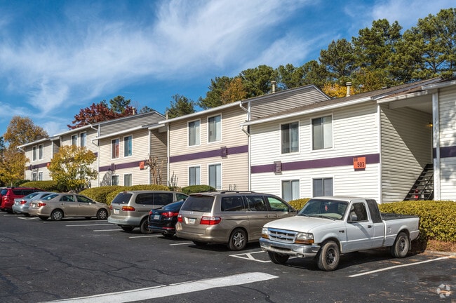
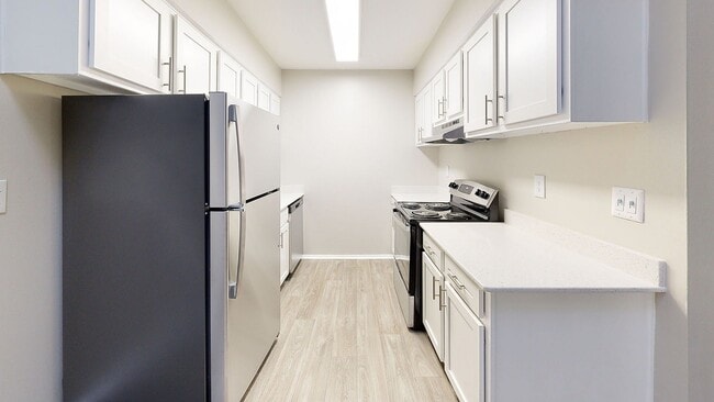
Property Record
8101 Colquitt Rd, Atlanta, GA 30350

NEARBY LISTINGS FOR SALE OR LEASE
-
-
View all Atlanta listings for sale on LoopNet.com
Property Detail
8101 Colquitt Rd
Apartment
Fulton
X
Georgia
13089C0005K
23.40 AC
2024
Sandy Springs
2025
Atlanta
010135
Atlanta-Sandy Springs-Roswell, GA
3,326,939 SF
06-0385-LL-036-7
DEMOGRAPHICS near 8101 Colquitt Rd
1 Mile
3 Mile
5 Mile
2024 Total Population
11,730
74,921
216,074
2029 Population
11,839
75,630
218,702
Pop Growth 2024-2029
+ 0.93%
+ 0.95%
+ 1.22%
Average Age
38
39
40
2024 Total Households
5,860
32,334
91,074
HH Growth 2024-2029
+ 0.87%
+ 1.05%
+ 1.32%
Median Household Inc
$72,899
$97,825
$104,620
Avg Household Size
2.00
2.30
2.30
2024 Avg HH Vehicles
1.00
2.00
2.00
Median Home Value
$480,687
$541,966
$505,927
Median Year Built
1985
1983
1986
Nearby Places
Map Layers
Map Styles
 Street
 Aerial
- Restaurants
- Banks
- Shops
- Fitness
- Groceries
PUBLIC TRANSPORTATION
AIRPORT
Hartsfield - Jackson Atlanta International
DRIVE
WALK
Distance
Hartsfield - Jackson Atlanta International
39 min
27.6 mi
Freight Ports
Georgia Ports - Savannah
DRIVE
WALK
Distance
Georgia Ports - Savannah
302 min
266.9 mi
Nearby Properties
Address
Land Use
TOTAL SIZE
Lot Size
Zoning
Address
Land Use
TOTAL SIZE
Lot Size
Zoning
485,132 SF
37.90 AC
OI
Address
Land Use
TOTAL SIZE
Lot Size
Zoning
258,909 SF
19.01 AC
X
Address
Land Use
TOTAL SIZE
Lot Size
Zoning
12,342,500 SF
125.51 AC
AC
Address
Land Use
TOTAL SIZE
Lot Size
Zoning
4,555,620 SF
12.41 AC
OI
Address
Land Use
TOTAL SIZE
Lot Size
Zoning
347,179 SF
18.24 AC
X
Address
Land Use
TOTAL SIZE
Lot Size
Zoning
292,537 SF
10.50 AC
ACOND
Address
Land Use
TOTAL SIZE
Lot Size
Zoning
7,258,269 SF
38.75 AC
AC
Address
Land Use
TOTAL SIZE
Lot Size
Zoning
792,356 SF
20.07 AC
R5
Address
Land Use
TOTAL SIZE
Lot Size
Zoning
1,909,285 SF
22.39 AC
OI
Address
Land Use
TOTAL SIZE
Lot Size
Zoning
10,614,240 SF
24.05 AC
A
Address
Land Use
TOTAL SIZE
Lot Size
Zoning
234,555 SF
12.18 AC
RM-HD
Address
Land Use
TOTAL SIZE
Lot Size
Zoning
8,014,916 SF
28.58 AC
R4
Address
Land Use
TOTAL SIZE
Lot Size
Zoning
10,866,920 SF
31.48 AC
AC
Address
Land Use
TOTAL SIZE
Lot Size
Zoning
3,714,740 SF
45.91 AC
A1
Address
Land Use
TOTAL SIZE
Lot Size
Zoning
647,376 SF
22.43 AC
AC
Address
Land Use
TOTAL SIZE
Lot Size
Zoning
2,461,880 SF
35.44 AC
OIC
Address
Land Use
TOTAL SIZE
Lot Size
Zoning
9,550,520 SF
25.59 AC
AC
Address
Land Use
TOTAL SIZE
Lot Size
Zoning
351,099 SF
17.26 AC
ALC
Address
Land Use
TOTAL SIZE
Lot Size
Zoning
287,388 SF
44.90 AC
ACOND
Address
Land Use
TOTAL SIZE
Lot Size
Zoning
305,733 SF
10.93 AC
OIC
Address
Land Use
TOTAL SIZE
Lot Size
Zoning
4,124,136 SF
19.85 AC
AC
Address
Land Use
TOTAL SIZE
Lot Size
Zoning
1,957,333 SF
19.86 AC
AC
Address
Land Use
TOTAL SIZE
Lot Size
Zoning
5,499,045 SF
22.17 AC
AC
Address
Land Use
TOTAL SIZE
Lot Size
Zoning
2,928,960 SF
22.67 AC
AC
Address
Land Use
TOTAL SIZE
Lot Size
Zoning
1,791,710 SF
27 AC
ACOND
Address
Land Use
TOTAL SIZE
Lot Size
Zoning
4,569,356 SF
33.31 AC
AC
Address
Land Use
TOTAL SIZE
Lot Size
Zoning
680,745 SF
8 AC
ALC
Address
Land Use
TOTAL SIZE
Lot Size
Zoning
690,426 SF
34.99 AC
AC
Address
Land Use
TOTAL SIZE
Lot Size
Zoning
1,069,100 SF
0.73 AC
A
Address
Land Use
TOTAL SIZE
Lot Size
Zoning
2,932,336 SF
20.37 AC
AC
The World's #1 Commercial Real Estate Marketplace
Connect with us
© 2026 CoStar Group
The information above has been obtained from sources believed reliable. While we do not doubt its accuracy we have not verified it and make no guarantee, warranty or representation about it. It is your responsibility to independently confirm its accuracy and completeness. Any projections, opinions, assumptions, or estimates used are for example only and do not represent the current or future performance of the property. The value of this transaction to you depends on tax and other factors which should be evaluated by your tax, financial, and legal advisors. You and your advisors should conduct a careful, independent investigation of the property to determine to your satisfaction the suitability of the property for your needs.